 Platform
Condition and response times are contractual.
Many concession and maintenance contracts set condition indicators, intervention deadlines and penalties. Meeting them is half the work; showing that you met them is the other half.

Solutions
All Solutions Overview RailEyes RailEdge Camera RailEyes Survey PlannerRailEyes TrackViewNear-Real-Time Railway StreamRailEyes ZoningRailEyes Vegetation DetectionRailEyes Map/Track/Lane MatchingRailEyes AnonymizationRailEyes DynamicsRailEyes MapmatchingRailEyes HeatmapsConsultingApplications
Surface damage: potholes and cracksSign condition and visibilityPatrol coverage and street recencyAsset inventory against the mapCorridor surveysVegetation managementRoads & Highways · AI road condition survey for concessionaires and contractors
RailEyes fits the vehicles already driving your network, such as patrol vans and maintenance crews. Each pass becomes a record of which kilometres were observed, when, by which vehicle, and what was visible.
On a real drive · A-4 Autovía del Sur, 19 October 2026
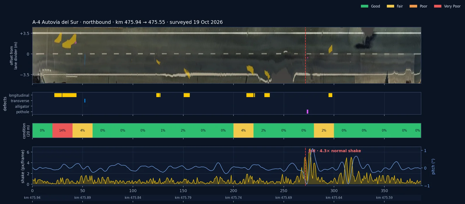
One pass on the A-4: anonymised at capture, calibrated, road damage detected, a jolt picked up from the camera's own motion, and the deteriorated stretch placed on the map.
The problem
Many concession and maintenance contracts set condition indicators, intervention deadlines and penalties. Meeting them is half the work; showing that you met them is the other half.
The network is driven constantly, yet what was seen often ends up in notes, phone photos and memory.
Between campaigns, signs get hidden by growth, barriers get struck, debris appears and potholes open.
Knowing what a stretch looked like at a given time and place settles questions that otherwise take days to answer.
What you get
Which kilometres of each carriageway were observed, when, and by which vehicle, and which stretches have not been observed for too long.
Every observation placed on the right road and carriageway, merged into one pass per stretch per vehicle.
Visible surface defects, each with image evidence and a location.
Sign detection, and signs whose visibility appears obstructed.
Jolts that shake the vehicle, picked up from the camera's own motion and placed on the chainage, where a pothole or a failed patch often sits.
Top-down imagery of the corridor at 2 cm per pixel, with each defect measured and every 20 m graded on a straight-line diagram.
Approximate size and distance from a single camera after a per-installation depth calibration: how large a defect is, how close growth is to a sign.
New, worsening and repaired findings, compared pass by pass on the same stretch.
Growth near signs, sightlines and barriers, building on the vegetation model used on rail.
Faces and number plates blurred automatically before review, so footage of public roads can be used under GDPR.
Observations referenced to your own kilometre points and asset inventory, exported as CSV or GeoJSON.
It does not replace laser pavement surveys: roughness (IRI), rutting and texture stay with specialist survey vehicles. RailEyes covers the visible condition between campaigns and shows where to send them. It is not a safety system and does not make automated decisions.
From one pass · A-4, October 2026
The same pass, rebuilt in 3D and laid flat: top-down imagery of the carriageway, aligned on its own lane markings, every defect measured, and each 20 m graded on a straight-line diagram together with the ride shake.
How it works
Step 1
A RailEyes camera on a vehicle that already drives the network. The road version runs on a standard 12 V vehicle supply. Footage from compatible dashcams can also be imported in bulk.
Step 2
Over mobile data, through a small gateway in the vehicle, or through a hub at your maintenance centre that uploads when vehicles return. Chosen per network.
Step 3
Faces and number plates are blurred before anyone reviews the footage.
Step 4
GPS and motion data are matched to the road network, by carriageway and by pass.
Step 5
Findings appear on a map with their image evidence. Your team confirms or rejects them, and those decisions improve the models.
Why RailEyes
Start with one corridor
1. Define
Agree the corridor, host vehicles, target conditions, privacy requirements and success criteria.
2. Equip and capture
Install on your patrol or maintenance vehicles. Your operations stay unchanged.
3. Review
Your team works with mapped findings and coverage for the pilot period.
4. Decide
Measure the results against the agreed criteria and against your current method, then decide whether to expand.
Questions operators ask
No. RailEyes fits the vehicles that already drive your network.
No. Laser surveys measure what a camera cannot, such as roughness, rutting and texture. RailEyes covers visible condition between campaigns and helps target them.
Faces and number plates are blurred before anyone reviews the footage. Hosting and retention are agreed with you.
No. A pilot runs on RailEyes infrastructure. Integration with your asset or maintenance systems can follow if you want it.
Data ownership, hosting location and retention are set out in your contract before any capture starts.
A top-down image of the carriageway aligned on its lane markings, every defect with its type, area, lane and chainage, condition graded in 20 m sections, a straight-line diagram and the ride jolts along the route.
Yes. Cities and regional road authorities can join the RailEyes Smart Cities Programme: a managed street survey, a report and a workshop. See the Smart Cities Programme.