Solution
A railway inspection platform that starts with evidence operators can trust.
RailEyes captures corridor evidence from active rolling stock, processes it through edge and cloud workflows, and gives railway teams a structured way to review vegetation, assets, anomalies, and route conditions on a rail-aware map.
Why it matters
Railway infrastructure teams need more frequent visibility, but raw video alone creates bandwidth, storage, privacy, and review burden. RailEyes is positioned around useful evidence, not more unmanaged media.
For operators
Less blind inspection. More location-aware review.
For investors
A capital-efficient route to railway infrastructure intelligence.
Product modules
Connected modules, one railway data foundation.
RailEyes modules are most credible when presented as one inspection stack: retrofit capture, selective edge upload, anonymization, rail location matching, AI-assisted review, and human validation.
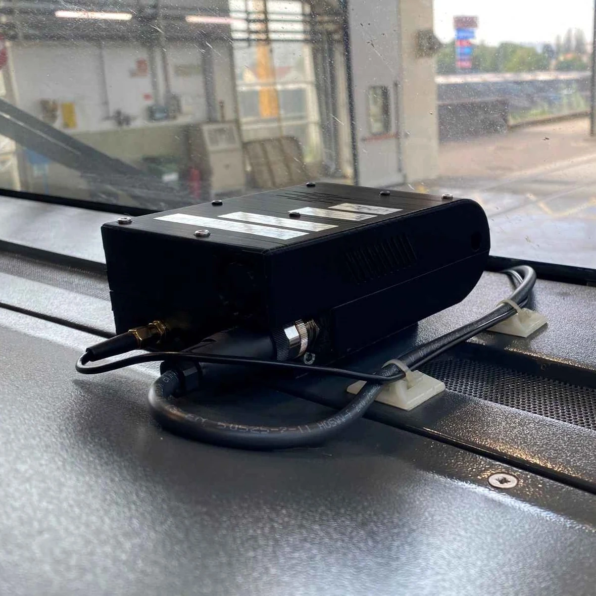
Hardware and Edge Intelligence
Software and Data Analytics
RailEyes TrackView
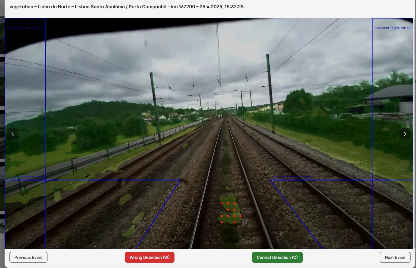
Map-based track review using anonymized still frames extracted from onboard video at distance or time intervals, so teams can inspect long corridors without moving full video around by default.
Project reporting describes TrackView review every 50-100 meters and a 90%+ reduction in data footprint compared with full-length video collection for typical review segments.
ExploreReal-Time Railway Stream
Live and near-real-time railway corridor streaming for operators who need immediate visual context from scheduled train movement, existing camera feeds, or RailEyes capture units.
Project reporting describes processed video records, route-linked media, thumbnails, map context, and selective upload workflows that support streamed review where connectivity and operator policy allow.
ExploreRailEyes Zoning
Location-aware object and obstacle review that separates trackside observations into operational zones such as LEFT, RIGHT, and DANGER.
The project reports describe a zoning proof of concept validated with synthetic on-track obstacles when real obstruction events were not available during the monitoring phase.
ExploreRailEyes Vegetation Detection
Railway vegetation intelligence using semantic segmentation for corridor growth, including high grass, low grass, tree trunks, tree tops, and miscellaneous vegetation classes.
The DriveTrust project implemented a production-grade vegetation pipeline with human-in-the-loop validation and retraining on real Portuguese rail network data.
ExploreRailEyes Map/Track/Lane Matching
Rail-specific location matching that connects GPS observations to tracks, segments, stations, and kilometer points instead of relying on road-oriented map matching.
Project reporting states that road map matching was unsuitable for the railway use case, leading to a custom rail network matching approach.
ExploreRailEyes Anonymization
Privacy-oriented video and image anonymization for railway review workflows where pedestrians, passengers, staff, or public spaces may appear in captured data.
The project reports describe automated anonymization pipelines, face blurring, thumbnail anonymization, and deletion of original non-anonymized video after processing.
ExploreRailEyes Dynamics
RailEyes Dynamics blends onboard inertial signals, visual corridor proof, and rail-specific map matching so abnormal motion patterns can be reviewed at the correct track location.
The hardware report states that onboard IMU data collection was validated for detecting train motion during the pilot, creating a foundation for route-linked motion review.
ExploreRailEyes Mapmatching
Hectometer-oriented matching of railway observations using GPS, motion context, and rail network structure for more actionable inspection records.
The project dashboards included filtering by track name, segment name, station, and kilometer ranges.
ExploreRailEyes Heatmaps
Aggregated visual intelligence for detecting repeated vegetation, asset, obstacle, and passenger-presence patterns across corridors and stations.
Project concepts included pedestrian density monitoring, route review, and map-based analytics that can be extended into corridor-level heatmaps.
Explore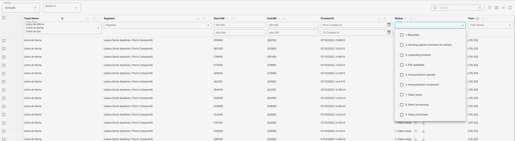
Review queue
Operational media becomes a structured inspection list.
The operator view is designed around clips, locations, filtering, anonymization status, and review priority rather than raw video folders.
Operator workflow
Capture, filter, anonymize, locate, review, and validate.
The workflow is intentionally practical. RailEyes captures what the corridor looked like, reduces unnecessary media transfer, protects sensitive imagery, ties evidence to the rail network, and lets experts validate what the AI has found.
- Edge capture for railway visual evidence, thumbnails, GPS, and device data.
- Selective upload and retry logic for intermittent connectivity.
- Vegetation, zoning, TrackView, anonymization, and mapmatching modules.
- Human-in-the-loop review for operational confidence and model improvement.