Plaça de Saragossa, València
37 road cracks, each a case with an ID
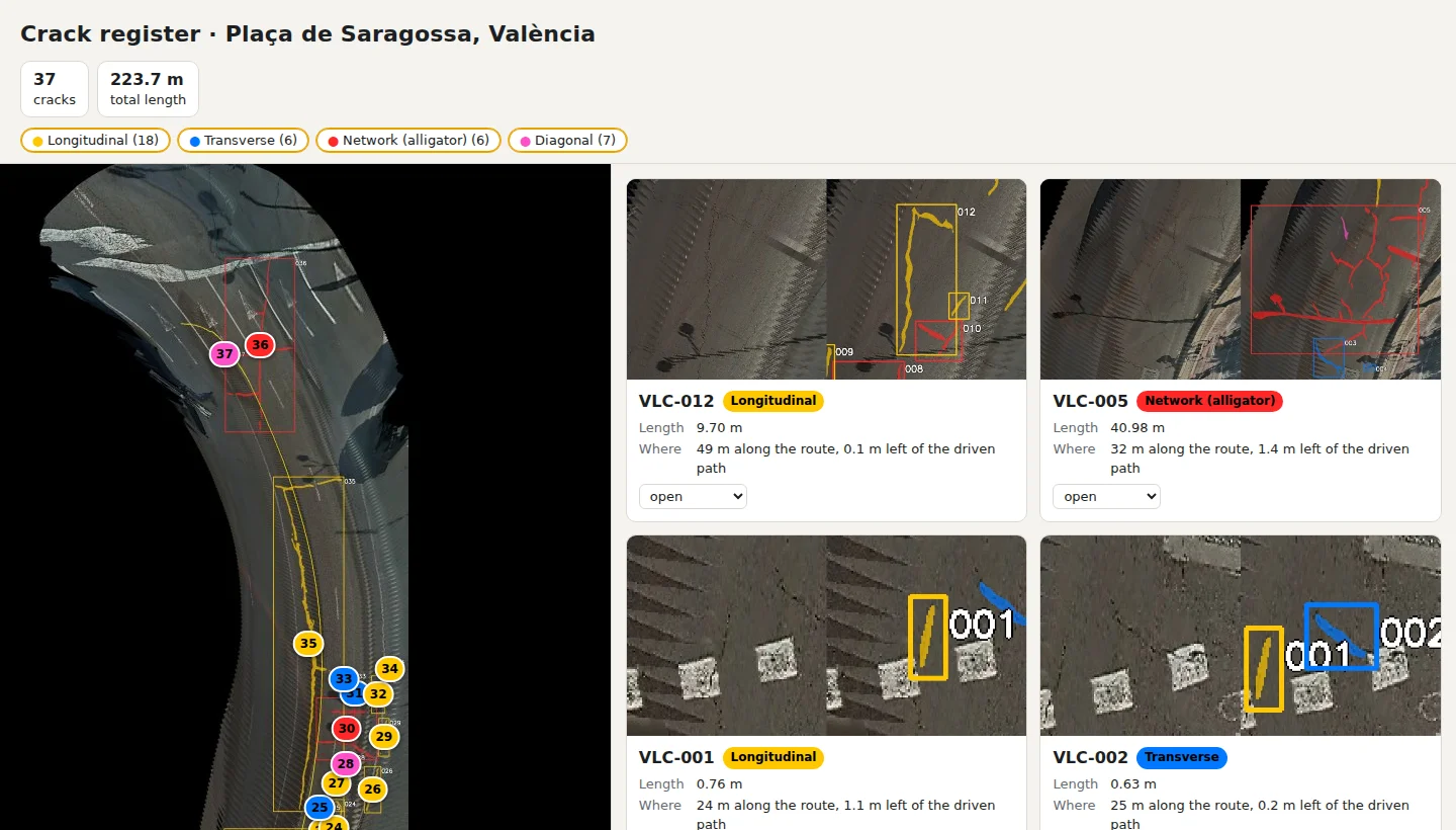
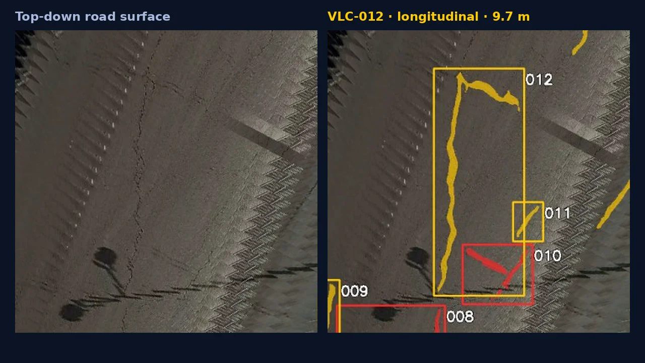
Every crack has a type, a length and a position on the map: 224 m of cracking in total. A reviewer checked all 37, and every one is a real crack: no false positives.
Solutions
All Solutions Overview RailEyes RailEdge Camera RailEyes Survey PlannerRailEyes TrackViewNear-Real-Time Railway StreamRailEyes ZoningRailEyes Vegetation DetectionRailEyes Map/Track/Lane MatchingRailEyes AnonymizationRailEyes DynamicsRailEyes MapmatchingRailEyes HeatmapsConsultingApplications
Surface damage: potholes and cracksSign condition and visibilityPatrol coverage and street recencyAsset inventory against the mapCorridor surveysVegetation managementSmart Cities Programme · Road condition digital twin for municipalities
Refuse trucks, sweepers and service vans already pass your streets every week. Join the limited-time Smart Cities Programme and discover how those routes could keep road and sign condition current: potholes, cracks and sign visibility, reviewed and mapped on your own priority streets.
Programme objectives
Four objectives, confirmed with each authority when the scope is agreed and reviewed together at the workshop.
Reviewed findings on your priority streets: surface damage, sign condition and sign visibility, each with an image, a location and a case ID.
Show whether vehicles you already run, such as refuse, cleaning or maintenance vans, could keep the picture current, and what that would cost.
A report, a findings file for your GIS and a workshop that ends in a decision record: what to fix first and what comes next.
One fixed, all-inclusive fee, a timeline of weeks rather than months, and the privacy, AI Act and procurement documents ready for review.
On a real drive · València and Castelló, 23 October 2026
One drive through València and Castelló: anonymised at capture, calibrated, analysed and placed on the map. Two of the findings, as the city would receive them:
Plaça de Saragossa, València
Every crack has a type, a length and a position on the map: 224 m of cracking in total. A reviewer checked all 37, and every one is a real crack: no false positives.
Castelló de la Plana
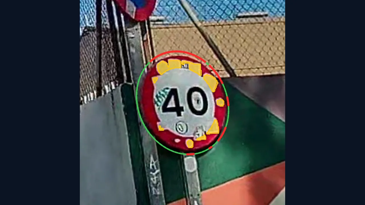
Stickers cover about a quarter of the red ring, the part that makes the sign read as a rule at a glance: 8 stickers in all. Flagged as an alert for sign maintenance.
From finding to work list
Each crack is a case with its own ID, type, length, position and status, pinned on the street. Your team works through a list, confirms or closes cases, and exports them for the works contractor.
What the city sees
Visible potholes on the carriageway, each with image evidence and a location on the map.
Cracked and deteriorating surfaces, located street by street so repairs can be grouped.
Stop signs and other signs hidden by growth, stickers or damage, before they become a safety issue.
When each street was last observed, and by which vehicle. Streets that have gone too long without a pass stand out on the map.
Coverage by district, neighbourhood and street, with pedestrian streets reported separately so percentages stay honest.
Overgrowth that blocks signs, sightlines or footways, building on the vegetation model used on rail.
Faces and number plates blurred automatically before review.
A prioritised work list, CSV or GeoJSON exports, and a one-page summary for council.
Up to 10 km · Two visits
Scope and required approvals are agreed before any collection.
Why it is different
A survey or a rating describes the network on the day it was made. RailEyes keeps the picture current, because the vehicles that capture it, such as waste collection, street cleaning and technical-service vans, are already on their routes. Every number links back to the passes and images behind it, and what has not been observed is shown as not observed.
The same platform runs on scheduled trains, with more than 1 million km of service and a completed contract with Comboios de Portugal and Infraestruturas de Portugal. See our references.
Corridor surveys from patrol vehicles, for concessionaires and maintenance contractors: RailEyes for Roads & Highways.
Share this page with your local authority, or introduce us by email at info@raileyes.eu.
Value for every team
One survey, five teams served. Each gets what it needs to decide, in a form it can use straight away.
A located list of defects with evidence, ready to turn into work orders, and a condition rating for each street section.
A findings file in CSV or GeoJSON, with your asset IDs where they match, that loads straight into your own systems.
One fixed fee, one invoice after acceptance, a written quote within five working days and a short, documented scope.
Anonymisation at capture, processing in France, a DPIA template, a local annex and the AI Act assessment, all ready before any recording.
A one-page summary for the council and a clear view of what a city-wide service would deliver and cost.
Flexible by design
The programme is fixed in price, not in shape. You decide what it looks at and how it fits your organisation.
Focus the report on surface damage, sign condition and visibility, verification after works, or coverage and recency.
Up to 10 km of streets you choose. More streets, a second pass or a recurring service are quoted on request.
Visits planned around your purchasing, approvals and local events, any time until 31 May 2027.
Findings in CSV or GeoJSON, matched to your asset IDs, with a condition rating aligned to the scale you already use.
Sign directly or through an authorised subsidiary or municipal company, by signed quote or purchase order.
If you continue: your own or your contractors’ vehicles, with flexible deployment on-premise, in the cloud or hybrid.
The report in English and in your language; every programme document in six languages.
RailEyes Survey Planner · for data room users
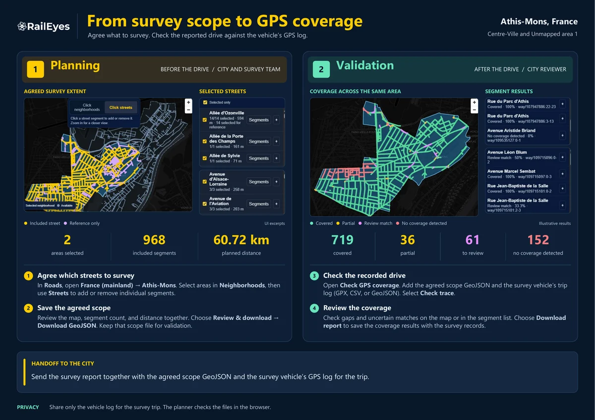
Agree the exact streets and neighbourhoods with RailEyes on the map before the drive. Afterwards, check from the vehicle’s GPS log alone that every planned street was covered: no footage is exchanged, and the files are checked in your browser.
Select neighbourhoods or single streets, then download the agreed scope as GeoJSON.
Load the scope and the GPS log to see each street as covered, partial or not covered, and keep the coverage report.
Open the planner with your data room account.

From first contact to report
Six to ten weeks from first contact to the report, depending mostly on your purchasing and local approvals. Up to 10 authorities until 31 May 2027.
To finish within the programme: quote accepted by 16 April 2027 and the first visit by 21 May 2027.
Open throughout Europe, with eligibility by country: which countries, and why.
The programme guide and fee, the full specification, sample deliverables on real data, and the privacy and legal documents for your teams.
Day 0
Request data room access, or book a 30-minute introductory call. Access requests are reviewed within two working days.
When you are ready
Submit your streets, a map link or a sketch and the question you want answered, from inside the data room. You receive a reference straight away.
Within 5 working days
We confirm eligibility, the road owner and the route, and post the quote in your data room folder. The fee is all-inclusive, travel included.
Your process
Accept by signed quote or purchase order. Where RailEyes acts as processor, the accepted quote incorporates the standard processor terms (07).
2 to 4 weeks
Local annex and DPIA, any permits, a public notice at least 7 days before recording, and the visit dates.
1 day
Kickoff with your team, then the recording of up to 10 km of agreed streets with a RailEdge Camera.
About one week later
The report and a 90-minute workshop: what to act on first, and how vehicles already on your streets could keep the picture current.
Within 10 working days
Report, findings file and workshop record in your folder. You confirm acceptance, then we invoice, payable within 30 days.
Questions
Austria, Belgium, Denmark, Estonia, Finland, France (mainland), Germany, Greece, Italy, Latvia, Lithuania, Luxembourg, Netherlands, Poland, Portugal, Spain, Sweden and Türkiye. Iceland and Norway on request.
This is a limited-time programme at a discounted, all-inclusive fee. To keep setup fast and compliant, we have prepared the groundwork for each eligible country in advance: the road authority rules, the recording and data protection requirements, and the documents your teams will need. That preparation is what makes a fixed fee and a short setup possible. If your country is not listed, contact us: we review other European locations case by case.
One fixed, all-inclusive fee per authority, with travel for both visits included. We invoice once your team has accepted the deliverables, payable within 30 days. The fee and the full terms are in the programme data room.
RailEyes uses a vehicle-mounted RailEdge Camera with anonymisation on board, not a phone, and every finding in the report is checked by a reviewer before it reaches your team. The programme also shows how your own vehicles could keep street condition current, rather than leaving you with a one-off snapshot.
Yes. Each street section receives a condition rating based on the reviewed findings. The rating rule is agreed with your team, so it can follow the scale your pavement management already uses.
A named lead, the priority streets and the question you want answered. RailEyes brings the camera and the vehicle, and no municipal equipment or IT integration is needed.
Faces and number plates are anonymised on the vehicle at the point of capture, and footage is processed on RailEyes servers in France. Your teams receive the findings and reviewed, anonymised excerpts.